

Taking the risk out of coastal living
IT’S complex, trying to develop an action plan for Inverloch on the likely impact of beach erosion, storm surges and ultimately the threat of permanent inundation as a result of climate change. We get that. But the Department of Environment, Land...

IT’S complex, trying to develop an action plan for Inverloch on the likely impact of beach erosion, storm surges and ultimately the threat of permanent inundation as a result of climate change. We get that.
But the Department of Environment, Land, Water and Planning and its Inverloch Regional and Strategic Partnership (RaSP) group promised to have its Cape to Cape adaption plan and specifically it’s resilience plan for Inverloch to us by mid-August this year.
It’s nearly October!
There’s a lot riding on it, including the preparation of a new Neighbourhood Character Plan for the Bass Coast Shire, and two months out from a State Election, it would be an opportunity to get both sides to commit some serious funding to the works needed.
So where is the report on the risks from erosion and the looming impact of storm surges and permanent inundation at Inverloch in particular, and the action plan to deal with it?
A major report in The Age during the week highlighted some of the issues being faced by Inverloch, in particular, those who own coastal property along Surf Parade.
LJ Hooker Inverloch branch manager, Euan Wightman, was quoted saying demand remained high for Surf Parade properties, with prices typically ranging from $1.35 million to $2.2 million.
He said prospective buyers trusted authorities to defend their properties from erosion, citing works undertaken to protect Bunurong Road.

“From a buyers’ perspective, they don’t seem to be concerned at all,” he said.
The Age report may have overstated the risk but it’s one that needs to be managed and DELWP representatives have conceded that planning is overdue.
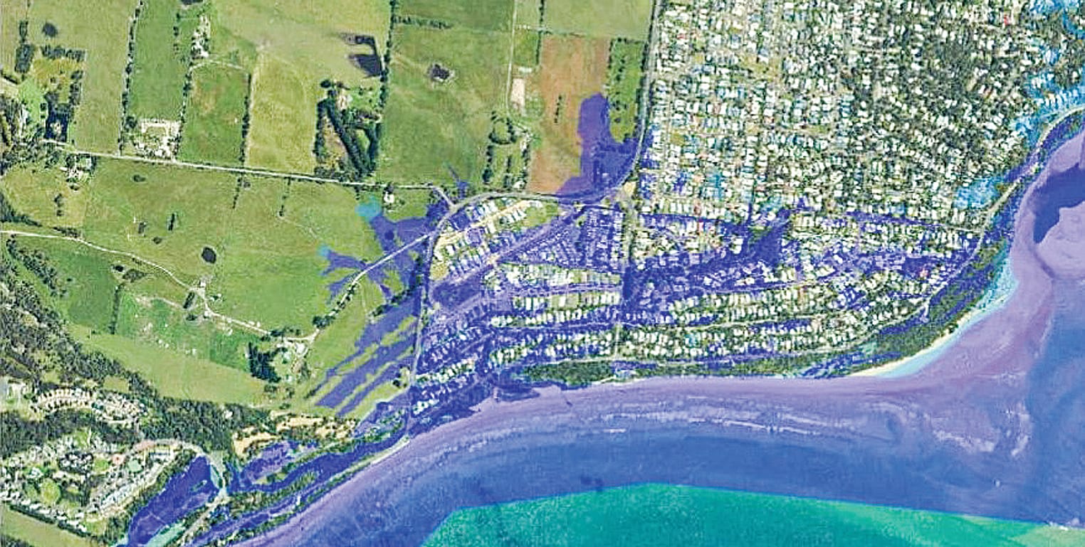
According to a recent risk assessment for Inverloch, the impact of erosion is a medium concern between now and 2040 but rises to “significant” between 2040 and 2070 depending on the sea level rise, either by 0.2m or 0.5m but then becomes “high” from 2100 onwards if sea level rises by an expected 0.8m.
Maps show permanent inundation of parts of Surf Parade and further into Inverloch’s residential area unless “adaptation” solutions are developed.
So, it can be managed with a range of measures between now and then, but the plan has to be finalised and funded including a range of measures from hard engineering solutions such as rock walls and even breakwaters to land use management, that is placing planning restrictions on development along the coast and even land acquisition as required, plus all the nature-based solutions including dune protection and the like.
Storm tide inundation is a “medium” concern between now and 2040 at Inverloch but become significant by 2070, again an issue which needs to be managed by a range of methods.
It is expected that the resilience and adaption plan for Inverloch, when it is finally produced, will outline some of these measures and the authorities can start looking at how and when they might need to be funded.
Where is the plan? We’re still waiting.


